1:02 PM
Among the most Greek islands, Mykonos island is located almost in the centre of the Cyclades complex. It is particularly famous for the cosmopolitan atmosphere, the exciting nightlife, the picturesque Cycladic architecture and the magnificent beaches that makes holidays in Mykonos a magnificent experience. There are many things to do in Mykonos Greece, an island perfect for people of all ages: walk along the narrow streets of Chora, see the sunset from Little Venice, stay in luxurious hotels and swim in exotic beaches. Super Paradise, Paradise and Kalo Livadi are fabulous places to swim and spend a day under the hot sun. In the evenings, head to Mykonos Town and enjoy a night out in the many bars and clubs.
12:51 PM
Istanbul is Turkey's most populous city as well as its cultural and financial hub. Located on both sides of the Bosphorus, the narrow strait between the Black Sea and the Marmara Sea, Istanbul bridges Asia and Europe both physically and culturally. Istanbul's population is estimated to be between 12 and 19 million people, making it also one of the largest cities in Europe and the world.
6:16 AM
Budapest is the capital and the largest city of Hungary, and one of the largest cities in the European Union. It is the country's principal political, cultural, commercial, industrial, and transportation centre, sometimes described as the primate city of Hungary. According to the census, in 2011 Budapest had 1.74 million inhabitants, down from its 1989 peak of 2.1 million due to suburbanisation. The Budapest Metropolitan Area is home to 3.3 million people. The city covers an area of 525 square kilometres (202.7 sq mi).[18] Budapest became a single city occupying both banks of the river Danube with the unification of Buda and Óbuda on the west bank, with Pest on the east bank on 17 November 1873.
The history of Budapest began with Aquincum, originally a Celtic settlement that became the Roman capital of Lower Pannonia. Hungarians arrived in the territory in the 9th century. Their first settlement was pillaged by the Mongols in 1241–42. The re-established town became one of the centres of Renaissance humanist culture by the 15th century. Following the Battle of Mohács and nearly 150 years of Ottoman rule, the region entered a new age of prosperity in the 18th and 19th centuries, and Budapest became a global city after its unification in 1873. It also became the second capital of the Austro-Hungarian Empire, a great power that dissolved in 1918, following World War I. Budapest was the focal point of the Hungarian Revolution of 1848, the Hungarian Republic of Councils in 1919, the Battle of Budapest in 1945, and the Revolution of 1956.
Cited as one of the most beautiful cities in Europe, Budapest's extensive World Heritage Site includes the banks of the Danube, the Buda Castle Quarter, Andrássy Avenue, Heroes' Square and the Millennium Underground Railway, the second-oldest metro line in the world. It has around 80 geothermal springs, the world's largest thermal water cave system, second largest synagogue, and third largest Parliament building. The city attracts about 4.4 million tourists a year, making it the 25th most popular city in the world, and the 6th in Europe, according to Euromonitor.
Considered a financial hub in Central Europe, the city ranked third on Mastercard's Emerging Markets Index, and ranked as the most liveable Central or Eastern European city on EIU's quality of life index. It is also ranked as "the world's second best city" by Condé Nast Traveler, and "Europe's 7th most idyllic place to live" by Forbes. It is the highest ranked Central/Eastern European city on Innovation Cities' Top 100 index.
Budapest is home to the headquarters of the European Institute of Innovation and Technology (EIT), the European Police College (CEPOL) and the first foreign office of the China Investment Promotion Agency (CIPA). Eighteen universities are situated in Budapest, including the Central European University, Eötvös Loránd University and the Budapest University of Technology and Economics.
6:11 AM
The Barron Falls is a steep tiered cascade waterfall on the Barron River located where the river descends from the Atherton Tablelands to the Cairns coastal plain, in Queensland, Australia.
Protected within the Barron Gorge National Park, the volume of water seen in the upper photo only occurs after substantial rainfall during the wet season. For much of the rest of the year, little more than a trickle is evident, due in part to the presence of a weir behind the head of the falls that supplies the Barron Gorge Hydroelectric Power Station located downstream in the gorge.
The Barron Falls may be viewed and accessed by road via the Kennedy Highway that crosses the Barron River upstream of the falls, near Kuranda. The narrow-gauge Kuranda Scenic Railway and the Skyrail aerial tram also leads from the coastal plain to the tablelands. The train stops at Barron Falls overlook, where passengers may disembark for several minutes. The Skyrail stops at two rainforest mid-stations, Red Peak and Barron Falls. The trail at Barron Falls Skyrail station leads through the rainforest to three separate lookouts providing views of the Gorge and Falls.
12:06 PM
The most popular destination from Badian is the Kawasan Falls, if you are staying right in Kawasan Falls please inform the resort the possible time of your arrival so they can send personnel to meet you at the arrival point. If you are taking a bus please inform the bus helper or the bus driver that you are going to Kawasan Falls, they know the place. Kawasan Falls is a 15 to 30 minutes walk from the national road. Note: As with all tourist attractions there will be pests offering a guide service which is totally not needed and they just irritate you anyway then ask for cash.
Kawasan Falls is a must see attraction while you’re in town, it’s a three-layered waterfall system located at Barangay Matutinao. The water is fresh and crystal clear. The magical landscape of Kawasan Falls is very cool and refreshing, an ideal paradise to anyone who loves and want to get intimate with nature. Enjoy the cold swim in the fresh, crystal clear spring water of Kawasan Falls.
Kawasan Falls is the most popular tourist destination in the town. It is well visited by both foreign and local tourists. Kawasan Falls is a three-tiered cascade of crystal clear waterfalls. It is the highlight of Barangay Matutinao located in the municipal of Badian. The waterfalls makes up the Matutinao River System, also awarded many times as the cleanest inland body of water in the country. The water coming from the falls is clean and crystal clear.
From Cebu City Kawasan Falls can be reach by bus right at Cebu South Bus Terminal or at Librando Trans Inc. It will take 3 to 4 hours travel to reach Matutinao, a barangay in Badian where Kawasan Falls is located. You need to hike 15 to 30 minutes from the entry point in Barangay Matutinao to Kawasan Falls. The riverbank will lead you to the very heart of Kawasan Falls. Along the way you can view several wild tropical plants, birds etc. Kawasan Falls is surrounded by lush, green rainforest and its magical landscape is truly a magical paradise.
At the highest accessible point of Kawasan Falls, the source can be found. It is called Kabukalan "The Source", the fresh water rushes from a small cave and pours over the stones. Climbing up to Kabukalan needs a bit extra energy because it’s quite far from the second level.
11:58 AM
Rize is the capital city of Rize Province in the eastern part of the Black Sea Region of Turkey.
The city is built around a small bay on the Black Sea coast, on a narrow strip of flat land between the sea and the mountains behind. The coastal strip is being expanded with landfill and the city is growing up the steep hillsides away from the coast. Rize enjoys a mild, extremely wet climate, vulnerable to storms coming off the Black Sea and therefore the surrounding countryside is rich with vegetation and is attracting more and more visitors every year.
Rize is a center for processing and shipping Rize Tea, the tea grown in the surrounding area. Tea was introduced in the region in the 1940s and 1950s, changing the destiny of the region, which was desperately poor until then. The city has a tea research institute founded in 1958 and tea gardens are the main sight in the town's panoramic view. Tea and kiwifruit plants are even planted in gardens around the town. The secondary activity is fishing. Rize is linked by road with Trabzon (41 miles [66 km] west), Hopa (55 miles [88 km] east on the Georgian border, and Erzurum (north). The nearest airport is in Trabzon.
Rize is a quiet town, a typical Turkish provincial capital with little in the way of night life or entertainment. However the border with Georgia has been open since the early 90's, the Black Sea coast road has been widened and Rize is now wealthier than in previous decades; there are more cars in the streets, higher buildings on the sea front, and some places for young people to go are opening up now. The visitors to the surrounding countryside also contribute to the economy of the town.
7:10 AM
Kopaonik is the biggest mountain range in Serbia, located in the southern part of the country. The highest peak of Kopaonik, Pančić's Peak, is 2,017 metres above sea level. Kopaonik was declared a national park in 1981. The area of the Kopaonik National Park is 118.1 km². The tourist resort on the Kopaonik mountain includes hotels, rest houses, ski lifts, excellent ski slopes and many other tourist facilities.
Kopaonik has a rich historical heritage. The area was an important mining center during medieval times with many Saxons operating in the area as miners. During those days there was an intensive trade with Ragusa (Dubrovnik). Besides old churches and monasteries, several medieval and pre-medieval fortresses built by Serbian dynasties that ruled the area can be found on Kopaonik. The nearest Serbian medieval castle is Maglič. Also, the monastery of Studenica is fairly close.
Kopaonik National Park is located 230 km away from Belgrade. It is well connected with the main transport routes in Serbia. The central part of Kopaonik with the tourist center and ski slopes is linked with the Ibar Highway by a modern tarmac road. The nearest airport is in Nis.
The Kopaonik mountain range is characterised by extraordinary natural beauty with vast expanses of grassland, picturesque forests composed of a wide variety of tree species, beauty spots and deep river gorges.
Deciduous forests and native coniferous woodland make up most of the forested land on Kopaonik. The flora is characterized by a large number of autochthonous plant species like the Balkan beech, fir, spruce, yew, several kinds of maple, pine and oak. The fauna is also diverse but its concentration varies, depending on the quality of the habitat. Kopanonik has many species of birds, such rock partridge, scops owl, red-backed shrike, and the wood lark. Soil erosion poses no threat as there is no logging and deforestation in the park.
7:06 AM
Abruzzo is a region of Italy, with an area of 10,763 square km (4,156 sq mi) and a population of 1.3 million. Its western border lies 80 km (50 mi) east of Rome. The region is divided into the four provinces of L'Aquila, Teramo, Pescara, and Chieti. Abruzzo borders the region of Marche to the north, Lazio to the west and south-west, Molise to the south-east, and the Adriatic Sea to the east. Geographically, Abruzzo is divided into a mountainous area to the west, which includes the Gran Sasso D'italia, and a coastal area to the east with beaches on the Adriatic sea. Abruzzo is considered culturally, linguistically, and historically a region of Southern Italy, although geographically it may also be considered central. The Italian Statistical Authority (ISTAT) deems it to be part of Southern Italy, partially because of Abruzzo's historic association with the Kingdom of the Two Sicilies.
Abruzzo is known as "the greenest region in Europe" as one third of its territory, the largest in Europe, is set aside as national parks and protected nature reserves: there are three national parks, one regional park, and 38 protected nature reserves. These ensure the survival of 75% of Europe's living species including rare species, such as the small wading dotterel, golden eagle, Abruzzo chamois, Apennine wolf, and Marsican brown bear. Abruzzo is also home to Calderone, Europe's southernmost glacier.
Visiting nineteenth-century Italian diplomat and journalist Primo Levi said that “forte e gentile” (strong and gentle) best describes the beauty of the region and the character of its people. "Forte e gentile" has since become the motto of the region and its inhabitants.
7:03 AM
Holbav is a village located about 20 km from Brasov.
1:08 PM
The Akatarawa Valley is a valley in the Tararua Range of New Zealand's North Island. It provides a link from the upper reaches of the Hutt Valley to Waikanae on the Kapiti Coast through rugged hill country. The valley is lowly populated and contains the localities of Reikorangi and Cloustonville. At the Hutt Valley end, the Akatarawa Valley is rugged and the Akatarawa River flows through it. The terrain is less difficult at the Kapiti end, where the Waikanae River flows through part of the valley on its route from its headwaters in the Tararuas to the Tasman Sea, and is met in the valley by tributaries such as the Ngatiawa River and the Reikorangi Stream.
Many residents are craftspeople or gardeners, and some gardens are open for public viewing. Also located in the valley is a former Salvation Army youth and family camp that has been upgraded and now operated by the Wellesley Group, and Staglands Wildlife Reserve, a conservation project established in 1972. It supports many native and rare birds, insects, and animals in conjunction with the New Zealand Department of Conservation.
An early proposal for the North Island Main Trunk Railway's route out of Wellington featured a line deviating from the Hutt Valley Line portion of the Wairarapa Line and running through the Akatarawa Valley to the west coast; see Haywards–Plimmerton Line. This proposal was considered in the 1870s but abandoned when the Wellington and Manawatu Railway Company chose a route directly out of Wellington via Johnsonville and Porirua. A railway through the Akatarawa Valley has not been seriously considered since this stage, though industrial tramways were built to serve private logging interests. The tramways and mills they served are now closed and little evidence remains of their existence.
5:48 AM
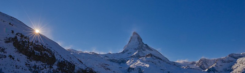
The Stanserhorn is a mountain in Switzerland, located in the canton of Nidwalden near to the border with Obwalden, with the peak at 1,898 metres (6,227 ft) above sea level.
It is a popular tourist destination, which can be reached from the adjacent town of Stans by a funicular railway and cable car, or via walking routes from Stans or Dallenwil.
5:46 AM
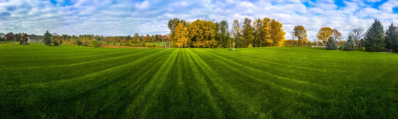
The Yorkshire Wolds present amazing chalk landscapes with dry valleys and stunning wildlife alongside vibrant market towns and ancient villages. Whether you're seeking peace and quiet or family days out there's something here for you on the 80 mile Way.
5:44 AM
The capital of New South Wales, Sydney is one of the largest cities in Australia, with an area of over 12,000 km² and over 4 million people. This vibrant city sits on a picturesque harbour, where the Sydney Opera House and Harbour Bridge give it an iconic look. Combining world-class attractions, beautiful beaches and wonderful weather, Sydney is a dream holiday destination.
5:40 AM
Aurlandsfjord is a fjord in Sogn og Fjordane county, Norway.